Qualicum Beach Walk
Qualicum Beach at EveryTrail
 This week we took a break from trails and decided to walk as far as we could in the eastern direction down Qualicum Beach from the Hall RD entrance. We got about 1K and a half before we were turned around from the rising tide. Lots of tourists on the beach in July, but not when you go east away from the town. We saw lots of starfish, crabs, as well as an eagle and great blue heron.

Hemer Park Trail
Hemer Park Trail at EveryTrail
Hemer Provincial Park is south of Nanaimo in the community of Cedar. The trail is very well marked, and there is great signage throughout to help you know where you are, although it is not that complicated. It is a series of very large loops with trails that go between, so you can choose how big of a loop you do. The trail follows Holden Lake, which is quite marshy and sometimes swampy.
Hemer Provincial Park is south of Nanaimo in the community of Cedar. The trail is very well marked, and there is great signage throughout to help you know where you are, although it is not that complicated. It is a series of very large loops with trails that go between, so you can choose how big of a loop you do. The trail follows Holden Lake, which is quite marshy and sometimes swampy.

Big Qualicum Hatchery Trail
Big Qualicum Hatchery at EveryTrail
If you're driving north up the Island Highway heading towards Qualicum Bay, right before you hit Henry's Kitchen follow the signs for Big Qualicum Hatchery. We were surprised by how big of a facility they have up there, it's a factory hatchery, we can't wait to check it out when it is actually salmon season.
Trailhead: End of Fisheries RD is the Hatchery, in the parking lot you'll find a map that shows you how to get to the trail, it is the hatchery road that follows the river, once we started on this road, within minutes we found a bridge and walked into the woods, we took the bait and opted for the forest trail.
After a short distance, this trail connected with a Quadders trail. We followed the quad trail until we hit the Inland highway. We actually ended up crossing the highway, we were really careful because of the dog, we wish there was alternate route. So, after crossing the friggen highway, we found the trail on the other side that simply went back under the bridge. To make it worse the trail was covered in Broom.
We couldn't find a connecting trail. Under the highway we had to hike up the underside of the overpass just to get back to where we first crossed the highway. Back on the quad trail, we ran into a quadder who was geocaching. He told us there was a connecting trail back at the underpass, which hurt us a bit, we looked hard, if there is a trail it is well hidden. We went back the way we came, Archer had reached his limit, he kept stopping and laying in the shade, the ATV trail was not covered at all and he was getting hot. We figure we'll try the trail again some other time, but next time we'll follow the Hatchery road instead of heading into the woods.
Trail Condition: 4/10 Once we left the hatchery compound, and ventures across the bridge into the woods, the trail was very narrow, overgrown, certainly not used that often. Once we connected with the ATV trail, it was very exposed, which meant it was dusty and hot. The terrain itself was very rocky, sandy and unpleasant to walk on...probably ideal for quaders/quadites/ATVers...what do they call themselves?
Convenience: 3/10 The hatchery had lots of signage, but once we hit the trail there was nothing. If we followed the hatchery road it probably would have been a different story.
Wildlife: 5/10 We did see a garter snake, which is pretty rare when your not looking for them. The rating here would be way higher if we came during salmon activity. We did see some small fish in the river. We saw a bunny run across the trail, Archer tried to chase it.

Union Bay Trail
Union Bay at EveryTrail
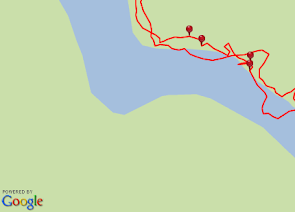
This was less of a trail and more of a walk through an old coal mine, no coal has been running through Union Bay since the 40's.
Trailhead: Directly across from Russel Street, there is a small parking lot, can't miss it.
The trail basically leads a big black hill, the Broom was in full bloom and about 20 minutes into our walk, allergies went haywire. We headed down to the beach for some relieve ourselves. The tide was out (hence why the map looks like we're walking in the ocean) so we played with Archer and hunted for crabs, the crabs were not hard to find if you looked into a tidepool you couldn't help but to notice all the moving crabs. The allergies never led up so we headed for home. In all we walked 3K in one hour, with lots of time on the beach.
Trail Condition: 3/10 - The conditions on some of the trails were fine, there was no signage, the trail once it hits the coal hill goes away for the most part. Luckily it was a small area and you couldn't stray far if you got lost. Also the Broom everywhere turned out to be a big problem.
Convenience: 4/10 - Easy to find but not a clearly marked trailhead, there was no signage throughout but this trail doesn't appear to be an official trail by any standards. There were red poles in the ground that are easy to spot if you ever stray from the trail, either way it wasn't a long walk.
Wildlife: 6/10 - We saw a mini-bunny, you can see him in the picture below hiding in the broom. Crabs on the beach, seabirds and small fish were all found during this walk.
Vistas 8/10 - The view of the mountains was quite nice all around.

Tag :
Broom,
Coal Mine,
Coast,
Comox Valley,
North Central Island,
Rock Beach,
Tidepooling,
Union Bay,
Vistas,
Pipers Lagoon Trail
Pipers Lagoon at EveryTrail
After getting muddied up at the Chase River Estuary we headed to Pipers Lagoon in Nanaimo with hopes that we could wash his feet in the water, plus "lagoon" sounds exotic! Trailhead: At the end Place RD in Nanaimo. We didn't stay for long, half hour to be exact, you can see from our trail that we walked we avoided going around the peninsula, and just headed back across the lagoon at low tide. The lagoon was full of crabs, oysters, clams, snails and sea ants, I assume.

After getting muddied up at the Chase River Estuary we headed to Pipers Lagoon in Nanaimo with hopes that we could wash his feet in the water, plus "lagoon" sounds exotic! Trailhead: At the end Place RD in Nanaimo. We didn't stay for long, half hour to be exact, you can see from our trail that we walked we avoided going around the peninsula, and just headed back across the lagoon at low tide. The lagoon was full of crabs, oysters, clams, snails and sea ants, I assume.

Chase River Estuary
Chase River Estuary at EveryTrail
Trailhead: Haliburton Street There is an exit there if you are taking the #1 North, you just have to be quick about it.
In the 1850's police were searching for two men who murdered a shepherd in this area of Nanaimo, they were able to track their steps along the river and catch the murderers. We also left some footprints in the mud as we ventured off trail to check out the Estuary, we immediately regretted our decision. Archer had a ball in the mud, as we were searching for the least muddiest area to walk Archer just ran through the mud like it wasn't a problem that he got himself terribly muddy.
Beyond the mud, this trail had a really nice boardwalk that went through the groomed portion of the estuary, that walk only lasted about 15 minutes, so we headed towards the "River walk" trail. This led us offtrail, and ultimately we reached a railway overpass, we didn't really want to find out how the dog would react to walking over a highway, he fell into a gap within the first couple rails, so we turned around and went back to the trail head, still muddy.

Fanny Bay Conservation Trail
Fanny Bay Conservation Trail at EveryTrail
This trail came as a recommendation from our good pal Cliff. He mentioned ice cream being available during this walk and we were intrigued.
It was one of the most enjoyable walks we've had, the trail goes along the shore of Fanny Bay which is conservation area, we saw lots of geese nesting. Once you reach the fork you have the option of going to the highway (where the ice cream store is) or towards "Bobs spring" as the signage called it. You can see we took both forks, luckily we did find the ice cream, sadly we did not find Bob's spring.
Along the portion between the fork and the highway we came across a few paths that connected with the main path. Archer will sometime take these trails and check them out, turns out they were pathways that led to some backyards, some of these paths were decorated, with things like bus stop signs.

Stamp Falls Trail
Stamp Falls at EveryTrail
Stamp River provincial park is just north of Port Alberni, with two trails - Stamp Falls & Stamp River. We headed towards the Falls and in hindsight we should have turned back, the falls and fish ladder attractions are about 5 minutes into the walk, but you can continue on into some uncharted areas. Or you can then head back and walk the Stamp River trail which goes along the bank in a north western fashion. We went southeast and the trail we found was odd, as you can tell by the squigley lines created by our GPS. This trail was much more advanced than what we were willing to do that day. In all we walked a total of 3K in an hour, with lots of time to admire the Fish Ladder, we will certainly will be returning here when the Salmon are spawning. In the meantime we found this video, you can see the fish jumping towards the end.

Stamp River provincial park is just north of Port Alberni, with two trails - Stamp Falls & Stamp River. We headed towards the Falls and in hindsight we should have turned back, the falls and fish ladder attractions are about 5 minutes into the walk, but you can continue on into some uncharted areas. Or you can then head back and walk the Stamp River trail which goes along the bank in a north western fashion. We went southeast and the trail we found was odd, as you can tell by the squigley lines created by our GPS. This trail was much more advanced than what we were willing to do that day. In all we walked a total of 3K in an hour, with lots of time to admire the Fish Ladder, we will certainly will be returning here when the Salmon are spawning. In the meantime we found this video, you can see the fish jumping towards the end.

Cable Bay Trail
Cable bay at EveryTrail
Word to us was that Cable Bay was a popular trail, many local Nanaimoans frequent this trail. We decided to check it out. Trailhead: End of Nicola RD in Nanaimo My GPS wasn't working for the first 15 minutes so I don't have the exact stats, but even with a bit of playtime at the beach the whole adventure lasted about two hours. We didn't find a loop trail, we believe it is just one way there and back.


Word to us was that Cable Bay was a popular trail, many local Nanaimoans frequent this trail. We decided to check it out. Trailhead: End of Nicola RD in Nanaimo My GPS wasn't working for the first 15 minutes so I don't have the exact stats, but even with a bit of playtime at the beach the whole adventure lasted about two hours. We didn't find a loop trail, we believe it is just one way there and back.


Newcastle Island Trail
Newcastle Island at EveryTrail
To get to Newcastle Island you have to take a ferry, you can catch it at Maffeo Sutton Park in Nanaimo. The Ferry costs a toonie and within Minutes you've reached Newcastle Island. Make sure you are aware of the return times, last thing you want to do is maroon yourself.
This walk was a great combination of Beach & Forest walk. There was a board that mentioned the wildlife that you see in the area, but we forgot to take a picture of it. Archer did however sniff out some kids smoking weed in the forest, they looked paranoid and guilty but we just chuckled to ourselves, waved at the kids and moved on.
The Island is close to Nanaimo, so you can watch the city. There is good signage, in all we walked 8K in two and half hours.


Paradise Meadows at Mt. Washington
 Just outside Courtenay BC there is the huge Strathcona Park, within the park is the Mt Washington ski area. Here you will find the Paradise Meadows trails, usually walked by snowshoers and cross country skiers, we decided to take Archer. This is April and there is still at least 4ft of compact snow on the ground, Archer had a ball, it wasn't too cold we were fine in just sweaters. This loop that we did was 2.7k in 50 minutes.
Paradise Meadows
Thetis Lake Trail
 This week we were in Victoria and decided to stop by Thetis lake on our way back up-island. This is a very popular and well used trail, there was a lot of traffic. The loop around the lake was exactly an hour, while we walked 3.4Km.
Thetis Lake
Englishman River Hatchery
 On your way to Englishman River falls, you can take a left at Englishmen River Rd, at the end of the road there is a trailhead for this fun one-way trail.
We walked for about 6K, one of the features during the walk was the Salmon hatchery, although we were out of season we'll check it out again in the fall.
Englishman River hatchery
Fossli Park Trail
 Fossli Park trail is on Sprout Lake, west of Port Alberni. It was 40 minutes to get from the road to the lake.
The most difficult part was navigating the car down Sterling Arm rd, it was bumpy ride but well worth it, just keep your eyes peeled for the Fossli trail sign that will indicate the trail head, also it looks like there are two trails, take the lower one to reach beach. The trail was short and there was a little miniature park and beach.
Fossli park trail
Colliery Dam Park
 The Colliery Dam is within the City of Nanaimo, the trailhead is easily found at the corner of Sixth and Wakesiah. It was a busy trail being in town and all, but there seemed to be a lot of different avenues that you could take, there was a quaint pond in the middle and some bridges that went over streams. We were able to do a 3K loop in just under an hour.